- Category
- War in Ukraine
Ukraine Shortens Kill Chain by 90 Percent Using Direct-to-Soldier Satellite Images
- Authors

-72b63a4e0c8c475ad81fe3eed3f63729.jpeg "Photo of Cyril Barabaltchouk")
")
A small unit of the Ukrainian Armed Forces operating in the country’s southeast recently used high-definition, near-real-time commercial satellite imagery to detect and strike a hidden Russian planning site, The Wall Street Journal reported on June 4.
The soldiers received the images directly on their phones, tablets, and laptops, allowing them to spot armored vehicles under thick tree cover and launch a successful drone attack.
We bring you stories from the ground. Your support keeps our team in the field.
Over the past six months, these small-team missions have utilized images from Vantor, a Colorado-based commercial satellite operator, to drastically improve the speed and precision of Ukraine’s drone strikes. Delivering geospatial intelligence directly to the battlefield has cut the time required to locate and hit Russian assets by up to 90%, technology providers and mission participants told The Wall Street Journal.
This deployment marks the first known instance of unclassified, commercial satellite imagery being sent directly to soldiers to guide real-time combat decisions, The Wall Street Journal reported. The capability stems from a trans-Atlantic collaboration between Vantor, the Dutch company Bravo1Alpha, US-based Persistent Systems, and the Ukrainian defense firm Burevii.
Traditionally, satellite intelligence underwent centralized reviews in Kyiv, a process that could delay the flow of information to the front lines by hours or even days. By bypassing this review, Vantor’s images now reach a soldier’s device in as little as 15 minutes.
A former Ukrainian soldier noted to The Wall Street Journal that older methods often delivered intelligence so late that it became stale and unactionable for units at the front.
The software accompanying the satellite feeds allows forces to compare current and historical images to track Russian movements. During a recent spring mission dubbed Starfall II, Ukraine’s Brigade 422 used the technology to identify a former agricultural facility that had been converted into a Russian ammunition depot.
After spotting fresh tire tracks consistent with military vehicles, the midrange strike team deployed attack drones, destroying the target, according to The Wall Street Journal.
Military analysts highlighted to The Wall Street Journal that compressing this “sensor-to-shooter cycle” is a defining tactical trend of the Russian invasion of Ukraine. While satellites face limitations such as thick winter cloud cover or an inability to track moving targets continuously, the rapid intelligence delivery offers a significant advantage.
Vantor’s network of 10 satellites covers 7 million square kilometers daily and provides coordinates accurate to within 5 meters, which is sufficient for targeting with 50-kilogram explosives.
The success of the program is already influencing Western military doctrine, according to The Wall Street Journal. While the US Special Operations Command has added software to provide near-real-time images to mobile devices, the US Army is still developing systems to give soldiers access free from headquarters reviews.
However, former intelligence officials warn that removing vetting intermediaries increases the risk of soldiers acting on incorrect information.
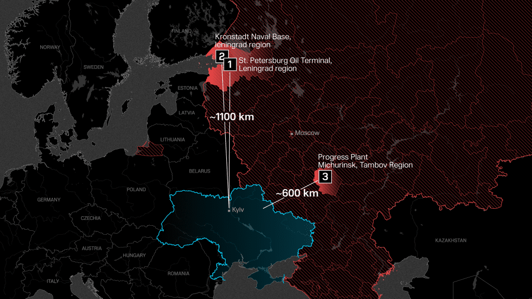
Ukraine’s expanding long-range drone campaign continues to threaten Russian infrastructure deep behind the lines. Ukraine’s Unmanned Systems Forces have recently launched a drone strike on the Kronstadt naval base near St. Petersburg—located more than 1,100 kilometers from the Ukrainian border.
The strike hit the Project 20380 corvette Boiky while it was stationed in dry dock at a key Baltic Fleet repair hub.
Discuss this article:
")
-111f0e5095e02c02446ffed57bfb0ab1.jpeg "Photo of Roman Kohanets")
, who was appointed as Ukraine’s interim Minister of Defense. (Source: SBU)")


")